In 2011, the Government of India launched the National Cyclone Risk Mitigation Project Phase–I (NCRMP-I) to protect vulnerable coastal communities in Andhra Pradesh and Odisha from cyclones. This initiative aimed to minimize the loss of lives and assets through various mitigation measures. In 2015, the project expanded to NCRMP-II, covering six additional coastal states: Goa, Gujarat, Karnataka, Kerala, Maharashtra, and West Bengal.
A key component of NCRMP-II was the development of Hydro-meteorological Resilient Action Plans (HmRAP) for six selected coastal cities: Panaji (Goa), Porbandar (Gujarat), Mangalore (Karnataka), Kochi (Kerala), Ratnagiri (Maharashtra), and Bidhannagar (West Bengal). The consultancy project for creating these plans was executed in a joint venture with Haskoning DHV Nederland B.V. and Tarutium (formerly Taru Leading Edge) in August 2020-2024.
The HmRAPs are designed to enhance the capacity of national, state, and urban local bodies to effectively plan for and respond to hydrometeorological hazards and climate change. These plans will guide decision-makers in improving urban resilience, integrating hydromet information into planning, and developing investment frameworks for climate-resilient initiatives. They identify specific local issues and propose actionable short--, medium---, and long-term steps to bolster urban services and infrastructure resilience.
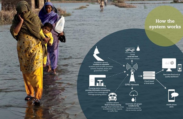
The consultant team developed six HmRAP for coastal areas. The journey began with an inception report and stakeholder engagement, detailing the methodology and plan for achieving project goals. Stakeholder consultations followed this to review past disasters, disaster risk management programs, and governance frameworks, incorporating feedback on local perceptions of hazards. High-resolution Digital Elevation Models (DEMs) and infrastructure mapping were done, and maps were created to understand critical infrastructure systems and urban utilities. Interim reports assessed current and future climate scenarios, including impacts from flooding, cyclonic storm surges, urban heat islands, flooding (pluvial and fluvial), air pollution, and other hazards. These reports also evaluated the cities' vulnerabilities and risks and developed a unique online Map Viewer to visualize these risks. Additionally, an institutional review assessed the capacity of local agencies and provided recommendations for strengthening their resilience strategies.
The project culminated in a final HmRAP document outlining actionable measures and investment strategies for short-, medium---, and long-term resilience improvements. This comprehensive plan aims to guide future actions and investments, improving the cities' ability to recover swiftly from extreme weather events and reducing overall vulnerability and risk.


