

Historical emissions, Himalayan hazards, and the question of who pays?
Author: Aastha Kirar
Floods are experienced in particular places, but the forces shaping their risk often extend far beyond the river basin in which the damage occurs. A destructive event may begin with extreme rainfall, unstable ice, a collapsing slope, or a temporary river blockage. Whether it becomes a disaster depends on a longer chain involving land use, infrastructure, warning systems, public institutions, and households’ capacity to protect themselves and recover.
The Rasuwa flood in Nepal illustrates this complexity. Nepal’s disaster-management authority describes an ice-rock avalanche that entrained sediment and water, developed into a debris flow and generated downstream flooding. Temporary channel blockages created further risks along the river corridor. An assessment by World Weather Attribution identifies warming-driven glacier retreat and permafrost degradation as processes that may have weakened the slope, while noting that their contribution to this specific collapse has not been quantified.
The remaining uncertainty concerns attributing a specific event, rather than the broader evidence of a changing climate. It leaves several questions to be examined together: how human-induced climate change activities alter the conditions in which hazards develop, how development creates exposure, and how unequal resources shape preparedness and recovery. Climate justice becomes more useful when it follows these relationships rather than treating a disaster as evidence for a verdict already reached.
The carbon ledger is cumulative
Climate politics often focuses on annual emissions, but climate physics requires a longer view. Warming from carbon dioxide is closely related to cumulative emissions, giving historical responsibility a physical basis as well as an ethical dimension.
The Global Carbon Budget estimates that the United States accounted for approximately 24 per cent of cumulative global fossil CO₂ emissions between 1850 and 2024. The present-day European Union contributed 16 per cent, China 15 per cent and India 4 per cent. The annual picture is different: in 2024, China accounted for 32 per cent, the United States 13 per cent, India 8 per cent and the European Union 6 per cent.
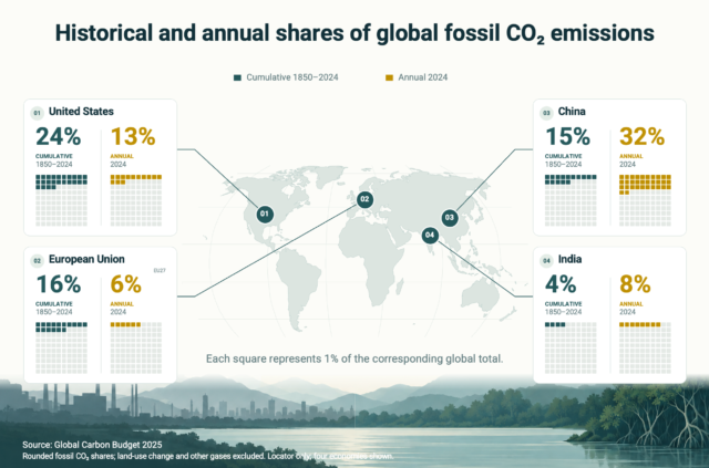
Figure 1 Cumulative (1850–2024) and annual (2024) shares of global fossil CO₂ emissions for four selected economies, illustrating how contributions differ across accounting periods. Rounded territorial estimates exclude land-use change and other greenhouse gases. Source: Global Carbon Budget 2025.
Both ledgers matter because they answer different questions. Historical emissions explain unequal contributions to accumulated warming, while present emissions determine how quickly the remaining carbon budget is depleted. Growing emissions in emerging economies do not erase the contribution of earlier industrialisation. Historical inequality, in turn, does not change the physical consequences of emissions released today.
These figures are not a complete ethical account. They cover territorial fossil emissions, assigning carbon to the country where it is released, and exclude land-use change. Consumption-based accounting reallocates emissions embedded in traded goods to their final consumers, while per-capita measures and financial capacity introduce further considerations. Different approaches illuminate different aspects of responsibility rather than producing one uncontested allocation.
Nepal’s Nationally Determined Contribution 3.0 describes its historical and current contribution to global emissions as negligible, while identifying high vulnerability and substantial requirements for international support. This mismatch between contribution, exposure and capacity remains central to climate justice, even though it cannot by itself explain every component of a particular disaster.
Climate change shifts hazards, while planning distributes losses
Understanding that distinction requires separating hazard attribution from consequence attribution. Event attribution examines whether warming changed the likelihood or intensity of an extreme event. Impact attribution considers how the changed hazard interacted with exposure and vulnerability, while source attribution examines the emissions contributing to the warming.
Nepal’s 2024 rainfall-driven floods demonstrate why these distinctions matter. A World Weather Attribution assessment found that climate models indicated about 10 per cent greater intensity and a 70 per cent higher likelihood of the three-day rainfall event relative to a climate 1.3°C cooler. The researchers reported substantial uncertainty because of the region’s complex terrain and differences between datasets. The assessment also cited a 386 per cent increase in Kathmandu Valley’s built-up area between 1990 and 2020, alongside floodplain development and disrupted drainage.
Climate change influenced the rainfall hazard, but development decisions shaped the distribution of damage. A percentage increase in rainfall likelihood cannot therefore be interpreted as the same percentage of losses attributable to climate change. Housing location, drainage capacity, bridge design, warning access and household resources remain part of the explanation.
This is also where respecting a river’s course becomes a practical planning requirement. A river occupies more than the channel visible during low flow. Its wider corridor includes floodplains, eroding banks, abandoned channels and areas into which it may migrate. Sediment deposition can raise the riverbed, while blockages may divert water into another channel. Established channel-migration assessment methods recognise that land can face erosion and channel-shifting hazards even where conventional inundation maps suggest lower risk.
River-sensitive planning combines historical channel positions, field surveys and hydraulic modelling with assessments of sediment movement, bank erosion and potential breach floods. A uniform setback from today’s riverbank cannot substitute for understanding these processes. Under risk-based zoning, new permanent development would be directed outside identified active channels and high-hazard flood, erosion and debris-flow corridors, while essential crossings would require assessment of alternatives and residual risks.
India’s NITI Aayog flood-management review similarly calls for floodplain zoning, recognition of the river’s right-of-way, and basin-scale assessment. Protecting a single reach without understanding the connected river can shift problems elsewhere. Existing settlements require a different response than restrictions on new construction: relocation also raises questions about access to safer land, services, and livelihoods, not physical exposure alone.
Himalayan hazards rarely occur one at a time
The Rasuwa event also illustrates why floods, landslides and glacial hazards cannot always be assessed separately. An initial collapse may gather water and sediment, obstruct a river and create temporary impoundments. Their failure can release additional flood pulses, extending the hazard well beyond its source. Research on Himalayan ice-rock avalanches identifies these transitions as an important challenge for risk assessment and infrastructure planning.
The physical cascade can become a wider systems failure. Damage to a monitoring station reduces information, a failed bridge constrains evacuation, and a power disruption weakens communications. Planning for one asset in isolation can therefore miss the consequences of several connected services failing together.
These processes operate within a changing cryosphere. ICIMOD’s glacier assessments estimate that Hindu Kush Himalayan glaciers lost approximately 12 per cent of their area and 9 per cent of their estimated ice reserves between 1990 and 2020. Its field-observation synthesis also found that only seven of 38 monitored glaciers met World Glacier Monitoring Service benchmark standards. The findings indicate both substantial change and important gaps in the capacity to observe it.
Climate is not the only influence on mountain stability. Geological conditions vary between valleys, including fractured rock, shear zones, weathered material and old landslide deposits. Drainage and groundwater conditions interact with these materials, while river erosion and excavation may remove slope support. The WWA assessment of the Rasuwa disaster also considers whether an earlier major earthquake weakened the rock mass over time, although its contribution to the subsequent slope failure remains unconfirmed.
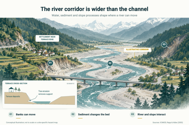
Figure 2 Conceptual illustration of channel migration, sediment redistribution and bank undercutting, showing how river-related hazards extend beyond the low-flow channel. The inset illustrates how toe erosion can reduce support beneath terrace deposits. Schematic, not a site-specific hazard map. Sources: Rapp and Abbe (2003); ICIMOD (2021).
Research on Joshimath similarly illustrates the interaction of geological structure, landslide deposits, drainage problems, and riverbank erosion. Describing the Himalaya as fragile is therefore a starting point, not an adequate site assessment.
For further development, these findings point towards integrating environmental appraisal with engineering-geological, geotechnical, hydrological and river-morphology investigations before locations and alignments are fixed. The assessment would address foundation conditions, potential slope failures, upstream hazard pathways, and the cumulative effects of roads, tunnels, hydropower facilities, and spoil disposal. Historical observations remain essential, but design also needs to account for plausible changes over the project’s operating life.
This does not reduce the importance of environmental assessment. It broadens the question from how a project affects its surroundings to how changes in slopes, rivers, and climatic conditions affect the project and connected communities. NITI Aayog has recommended conducting a disaster impact assessment alongside an environmental impact assessment for major projects in ecologically sensitive regions. The practical significance of such scrutiny depends on whether its findings can change a site, design or approval decision.
Monitoring and warning systems remain necessary where risk cannot be avoided. Satellite observations, targeted ground-based instruments, river gauges, and community reporting need to connect with decision-making authority, accessible communication, and feasible evacuation. World Weather Attribution found that warning systems helped protect downstream communities, but the speed and scale of the cascade exceeded their capacity to provide sufficient lead time in the worst-affected areas. Better detection cannot guarantee sufficient warning for every rapid collapse, so safer siting and preparedness remain relevant even where monitoring improves.
In an interview with The New Indian Express, glaciologist Anil V. Kulkarni proposes a High Altitude Mountain Regulation Authority and emphasises the need to assess climate impacts on infrastructure. Extending that idea across connected basins raises the possibility of a Himalayan Scientific Risk Council, linked to national review bodies rather than replacing their statutory authority.
Such a council could build on existing regional platforms and the expert dialogue convened by ICIMOD and Nepal’s government, which brought together participating countries and specialists to develop a joint approach to cascading mountain risks, monitoring and early warning. A basin-based mandate would include downstream settlements below high-altitude source areas. Its practical effect would depend on sustained data sharing, independent expertise, community participation and formal consideration of its recommendations within national approval processes.
Responsibility is shared, but not equal
The UN climate convention recognises common but differentiated responsibilities and respective capabilities, with developed countries expected to take the lead. This provides a basis for differentiated action, but not a simple calculation of responsibility for every damaged asset.
Nepal’s limited contribution to warming supports its case for international support without removing domestic responsibility for land-use regulation, infrastructure siting, and preparedness. Conversely, evidence of unsafe development does not erase climatic influences or establish that Nepal bears the entire burden of adaptation. These responsibilities apply to different parts of the same risk and need to be examined together.
National averages also conceal inequality within countries. Lucas Chancel’s analysis of global carbon inequality estimates that the highest-emitting 10 per cent of the population accounted for 48 per cent of global greenhouse-gas emissions in 2019, while the bottom half accounted for 12 per cent. It found that most inequality in individual emissions occurred within countries rather than between them.
A low-income household in a historically high-emitting country does not have the same footprint or capacity as a wealthy investor. Equally, businesses and affluent households in a lower-emitting country cannot be treated as equivalent to subsistence farmers simply because they share a national boundary.
Climate justice consequently concerns both international obligations and domestic distribution. It asks who contributed, who benefited and who controls decisions, but also whose losses are recognised and whose priorities shape protection. Scientific assessment informs these choices; it does not replace public deliberation over acceptable risk, livelihoods and displacement.
The question of who pays
The compensation debate surrounding Nepal’s flood brings historical responsibility into diplomatic discussions on climate impacts and shared responsibility, rather than a compensation demand directed at particular countries. The distinction matters because an ethical claim for greater support is not a finding that particular emitters caused a specified share of an event’s losses. s
The financing imbalance remains substantial. UNEP’s Adaptation Gap Report estimates developing-country adaptation needs at US$310–365 billion annually by 2035, compared with US$26 billion in international public adaptation finance in 2023. The comparison places future annual needs at 12–14 times the observed flow, rather than measuring a same-year shortfall.
Nepal’s National Adaptation Plan identifies an indicative requirement of US$47.4 billion through 2050, including US$45.9 billion in external support. These are planning requirements, not secured funds. Its objective of directing 80 per cent of international climate finance to local implementation also raises an important question about access: how much support will reach the institutions and communities responsible for managing risk on the ground?
The form of finance matters as much as its volume. Borrowing can restore damaged infrastructure while creating repayment obligations that constrain future public spending. Loans may suit investments with dependable revenues, but public goods such as monitoring, preparedness and social protection do not necessarily generate the income needed for repayment. UNEP therefore cautions against increasing the proportion of debt instruments borne by vulnerable countries. Grants and loans have different implications for how recovery costs are distributed over time.
Adaptation and loss-and-damage support address related but different needs. Adaptation reduces foreseeable harm, while loss and damage includes impacts that remain despite risk reduction or exceed available adaptive capacity. Nepal’s climate commitments recognise that not all risks are avoidable. Loss of livelihoods, cultural connections and ecosystems cannot always be addressed through replacement-cost accounting or physical reconstruction.
Nor is an adaptation project automatically equitable. A protective structure may transfer risk downstream, while relocation can reduce exposure but undermine access to land, employment and social networks. These are risks of maladaptation discussed in the IPCC’s assessment of impacts and adaptation. Low-carbon infrastructure requires similar scrutiny: renewable electricity generation does not by itself establish that a hydropower project is safely located or equitably governed.
Attribution science can strengthen the evidence informing support, but making precise event attribution a rigid condition would create difficulties for poorly monitored mountain regions. A needs-based approach would distinguish humanitarian assistance from the evidence required to assess longer-term climate risks and responsibility. Where event attribution remains uncertain, that uncertainty can be disclosed and investigated without treating it as evidence that climate influences are absent.
Before the next flood
The Rasuwa flood should not become shorthand for either a disaster entirely caused by climate change or one explained entirely by local development. Its wider significance lies in the interaction of cumulative emissions, changing hazards, geological conditions, river behaviour and unequal capacities to respond.
Climate justice remains relevant precisely because these responsibilities overlap without being identical. International support can strengthen scientific capacity and safer development, while better planning can prevent new exposure without eliminating the need for adaptation and recovery finance. Transboundary cooperation can improve knowledge and warnings, but its practical value depends on how that information informs decisions about river corridors, slope conditions and the rights of affected communities.
The question of who pays cannot be separated from what is built, where it is built and who bears the remaining risk. Examining those choices together brings the discussion beyond a single explanation of the disaster and towards the conditions that will shape future losses.
References
Ahmed, R., Bhardwaj, A., Sam, L., & Van Tricht, L. (2026). Ice-rock avalanches in a warming Himalaya indicate pathways toward effective preparedness. Communications Earth & Environment, 7, Article 217.
Awasthi, S., Jain, K., Sahoo, S., Kumar, R., Goswami, A., Joshi, G. C., Kulkarni, A. V., & Srivastava, D. C. (2024). Analyzing Joshimath’s sinking: Causes, consequences, and future prospects with remote sensing techniques. Scientific Reports, 14, Article 10876.
Chancel, L. (2022). Global carbon inequality over 1990–2019. Nature Sustainability, 5, 931–938.
Choubey, J. (2026, September 1). Interview: ‘India needs high altitude body to guide Himalayan growth’. The New Indian Express.
Friedlingstein, P., O’Sullivan, M., Jones, M. W., et al. (2026). Global Carbon Budget 2025. Earth System Science Data, 18, 3211–3288.
Government of Nepal, Ministry of Forests and Environment. (2021). National Adaptation Plan 2021–2050.
Government of Nepal. (2025). Nationally Determined Contribution (NDC) 3.0.
Intergovernmental Panel on Climate Change. (2022). Climate change 2022: Impacts, adaptation and vulnerability. Cambridge University Press.
International Centre for Integrated Mountain Development. (2025). HKH DRR Hub 2025: Accelerating inclusive resilience and risk-informed investment in the Hindu Kush Himalaya.
International Centre for Integrated Mountain Development. (2026, March 18). Hindu Kush Himalaya glaciers losing ice at double the rate since 2000, new ICIMOD report confirm.
International Centre for Integrated Mountain Development. (2026, September 16). Learning from disaster: ICIMOD convenes international experts following Rasuwa Gyirong flood.
National Disaster Risk Reduction and Management Authority. (2026, September 1). Rasuwa-Bhotekoshi flood: Search, rescue and relief response, Situation Report No. 1. Government of Nepal.
NITI Aayog. (2021). Report of the committee constituted for formulation of strategy for flood management works in entire country and river management activities and works related to border areas (2021–26).
Rapp, C. F., & Abbe, T. B. (2003). A framework for delineating channel migration zones (Publication No. 03-06-027). Washington State Department of Ecology.
The Times of India. (2026, September 2). ‘Not charity’: Nepal seeks compensation from major industrial emitters for deadly flood.
The Times of India. (2026, September 4). Nepal minister clarifies ‘compensation from world’ remark after flash floods: What he said.
United Nations. (1992). United Nations Framework Convention on Climate Change, Article 3.
United Nations Environment Programme. (2025). Adaptation Gap Report 2025: Running on empty.
World Weather Attribution. (2024, October 16). Rapid urbanisation and climate change key drivers of dramatic flood impacts in Nepal.
World Weather Attribution. (2026, September 17). Rapid warming in the Himalaya exacerbates geohazard cascades beyond adaptation limits.
